One of the first hikes I took in Korea was a portion of the Seoul Fortress Wall. I blogged about it back in October 2012. I felt like I was reliving a piece of history walking next to that wall. After that experience we hiked several more pieces of the wall, but I really wanted to hike the entire wall in one day to get an idea of the size of ancient Seoul. So we began to plan. I really love planning! Because a good portion of the wall has been destroyed over the years, this hike took a great deal of research. We were determined not to get lost. So last fall, with several maps in hand, along with our GPS tracking devices built into our phones, we were ready to hike the entire Seoul fortress wall in one day.
We met up with our friends (who were crazy enough to agree to do this with us!) near the Army base at 7:30am carrying backpacks, snacks, drinks and subway cards. Subway cards for a hike you ask? Yes, we needed to get to the wall, and the easiest way to do this was by subway. Here we are all waiting for the subway train.

The kids were all incredibly excited.

And here we are at our beginning point on the Seoul fortress wall -- Namdaemun gate. You can see it peaking over our heads. This was traditionally the southern most entrance into the city of Seoul, and our starting point. We were all ready to get this hike going.

Because Seoul has grown so much over the years, much of this portion of the wall was missing. We had our maps, though, and with the help of these tiny little signs...

...we made our way through the city following what would have been the wall.
There were a total of 8 gates in the original wall -- four great gates and four small gates -- all built between 1396 and 1398. Six of them still exist today, and we were able to see them on our hike. The Seodaemun (west) gate, however, was destroyed and never rebuilt. You can see the red wall behind us. This was built as a memorial for that gate.

At each of the four great gates there was a little visitor's center where you could stamp your hiking map.

Here's a picture of the map.
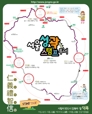
The big red circles are where the four great gates are located. At each one you can stamp your map. When you have four stamps, you can turn in your map for a prize.
I love prizes.
On we went. From here we started to leave the city and head for our first mountain -- Inwangsan.


Having lived in Utah for several years I use the terms mountain and hiking loosely. Most mountains here in Korea have stairs built into them. If you have bad knees, this is definitely not the hike for you. I wish I had counted the total number of stairs we climbed that day. It was an insane number. The picture above was a very common sight.
Here is picture looking down on the section of fortress wall we just hiked.

You can see Namsan in the distance with Seoul Tower on it. That would be our fourth and final mountain we would climb toward the end of our hike.
It was a shame the weather was so hazy. The view could have been so much prettier.


This was the highest point on the mountain so we all had to take turns standing on it.


We saw these little military installations all over the mountains. They were built in response to a 1968 assassination attempt on South Korea's President Park Chung He by a group of Norther Korean commandos. I'm guessing no one comes over these mountains unannounced anymore.

And if they do, Ryan's going to push this boulder on them.

We descended Inwangsan and headed into the little town of Buam-dong to prepare for our next mountain. Here's one of the small gates still remaining. Notice how wet Ryan's hair was. It was incredibly hot that day.

We had to register ourselves with our passports to hike the next mountain -- Bugaksan. Because this section is the closest to the Blue House (the President's house), there is security everywhere. It became very difficult to take pictures. You are only allowed to take them at designated photo spots.
And what did we find as we headed to Bugaksan? More stairs of course.

This picture does not do the steepness of this climb justice. These stairs went on forever.
From Bugaksan, you could look back on the last mountain we just went over. Notice the fortress wall to the left zigzagging down the mountain. While these mountains may not be super tall, the climb sure is a steep one.

Again, a photo at the top of this mountain.

Here is the third great gate -- Bukdaemun, or the north gate.


The kids even found a deer to ride. How convenient. Unfortunately, it didn't move, so they had to continue on foot with the rest of us.

On the way back down the mountain we found these great air guns. They are used to blow the dirt off your shoes. Great idea!

We soon found better uses for them though.

The kids had a blast with them.

We got quite a few stares from the people around us as we proceeded to dry every part of our bodies, and those of our friends. I know it's not what it was intended for, but man, it sure worked well!
We left Bugaksan and headed back into the city.


Soon it was time for lunch at Lotteria. We gave ourselves about 20 minutes to scarf down some Korean fast food, and we were on our way again.


We found another small gate here.

Then we were off to hike our third moutnain -- Naksan. This one was a bit of a reprieve as it wasn't very steep or tall.


It was amazing to see how the city grew up around the wall.


This is the wall to our right

We finally reached our fourth and final gate -- Dongdaemun, or east gate. I love this gate. I shop in this area all the time and love to see this traditional structure smack dab in the middle of modern, bustling Seoul. It's beautiful.

We all had to get our final stamps.


And then we turned in our maps! We overwhelmed the poor man working here at the Dongdaemun gate. He didn't have enough prizes to hand out at first. He had to go find more.

And what was the prize you ask? This awesome commemorative button Ryan is wearing.

Yup. A button. We all wore it with pride.
But we weren't finished our hike yet. We still had several miles to go and another mountain to climb.
We left the Dongdaemun gate and meandered our way through the shopping district. Because the wall is non-existent here, it was tricky trying to figure out exactly where to go.

I've never been on a hike that looks like this before. :)

We found some fun little places to play.

Eventually we made our way to our last small gate of the day...

...and finally picked up the last section of the Seoul fortress wall. It was nice to have the wall to follow again. It made navigating so much easier!

Here was our last mountain of the day -- Namsan, or south mountain. We didn't take a lot of pictures going up the mountain, because by this time, we were all tired. There were, what felt, like a billion stairs on Namsan on which we left gallons of sweat. By this point we were all anxious to finish.

Coming down Namsan was a beautiful feeling.


And even more beautiful was seeing Namdaemun gate, our final destination, off in the distance. It's the tiny little roof over the yellow tree in the middle of the picture.


It's hard to believe that this was once the southern-most point of Seoul.
The last few steps seemed to take forever.


Then before we knew it, we were back to where we started...9 hours and 14 miles later.

Lane was wearing a GPS and mapped out this route of our hike -- mile by mile. Pretty cool.

Of course, we had to take a picture at the end, all smiling for the camera...

...but this is how we truly felt.

It was definitely the most unique hike I've been on. One I will remember for a long time. Thanks to everyone who came and made it such a fun experience!
Kim, can you post a link to the turn by turn directions through the more difficult parts of the city?
ReplyDelete